


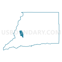
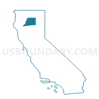
Voting District 20145, Shasta County, California
About
Outline

Summary
| Unique Area Identifier | 544227 |
| Name | Voting District 20145 |
| County | Shasta County |
| State | California |
| Area (square miles) | 39.69 |
| Land Area (square miles) | 39.21 |
| Water Area (square miles) | 0.48 |
| % of Land Area | 98.80 |
| % of Water Area | 1.20 |
| Latitude of the Internal Point | 40.68577930 |
| Longtitude of the Internal Point | -122.51677020 |
Maps

Graphs
Select a template below for downloading or customizing gragh for Voting District 20145, Shasta County, California


Neighbors
Neighoring Voting District (by Name) Neighboring Voting District on the Map
- Voting District 10040, Shasta County, CA
- Voting District 10060, Shasta County, CA
- Voting District 10065, Shasta County, CA
- Voting District 20110, Shasta County, CA
- Voting District 20150, Shasta County, CA
- Voting District 20180, Shasta County, CA
- Voting District 20185, Shasta County, CA
- Voting District 40405, Shasta County, CA
Top 10 Neighboring County Subdivision (by Population) Neighboring County Subdivision on the Map
Top 10 Neighboring Place (by Population) Neighboring Place on the Map
Top 10 Neighboring Elementary School District (by Population) Neighboring Elementary School District on the Map
- Shasta Union Elementary School District, CA (2,273)
- French Gulch-Whiskeytown Elementary School District, CA (439)
Top 10 Neighboring Secondary School District (by Population) Neighboring Secondary School District on the Map
Top 10 Neighboring Unified School District (by Population) Neighboring Unified School District on the Map
Top 10 Neighboring State Legislative District Lower Chamber (by Population) Neighboring State Legislative District Lower Chamber on the Map
Top 10 Neighboring State Legislative District Upper Chamber (by Population) Neighboring State Legislative District Upper Chamber on the Map
Top 10 Neighboring 111th Congressional District (by Population) Neighboring 111th Congressional District on the Map
Top 10 Neighboring Census Tract (by Population) Neighboring Census Tract on the Map
- Census Tract 124, Shasta County, CA (4,100)
- Census Tract 107.02, Shasta County, CA (3,896)
- Census Tract 116, Shasta County, CA (3,877)
- Census Tract 106.03, Shasta County, CA (1,394)